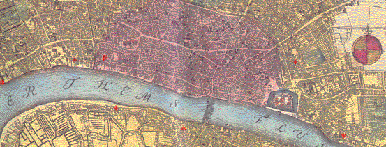
Red stars indicate (clicakable) glass house sites. The purple area represents the (walled) city of London, most of which was destroyed in the 1666 fire. In several cases there was more than one glass house in each area shown by a star. Individual glass house pages summarise the evidence there is as to when the sites were working, but links only work where there was a glass house working in this period. All the sites marked are quite close to the Thames, which was the main source of transport. There was a further site on the banks of the Thames to the east of London at Greenwich
Two known sites are not specifically mentioned. The first was at Broad Street where a drinking glass house had been working since the 1620s. This probably closed down early in the period covered, probably in the 1650s. The other one was an experimental glass house set up to make high-quality glass by a glass maker called de la Cam in Rutland House in Chaterhouse Yard. This lay just outside the city boundary, north of St Paul's Cathedral. The venture was not a success, but the glass house or one very close-by, continued in use well into the 18th century, making bottles.
The A-Z of Restoration London (based on Ogilby and Morgan's map of 1676), published by the London Topographical Society, 1992.
The A-Z of Georgian London (based on John Rocque's map of 1746), Published by Harry Margary in association with the Guildhall Library, 1981.
Trease, G., Samuel Pepys and his world, Book Club Associates, 1973.