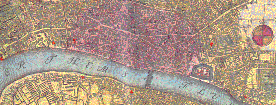
Red stars indicate (clicakable) glass house sites. The purple area represents the (walled) city of London, most of which was destroyed in the 1666 fire. In 1696 there were said to be nine London glass houses producing 'Flint, Green and Ordinary' glass (including drinking glasses). There are only seven stars shown marking sites, because in four cases there was more than one glass house in each area. Individual glass house pages summarise the evidence there is as to when the sites were working, but at this stage it is not possible to compile a definitive list of which nine were working in 1696. All the sites marked are quite close to the Thames, which was the main source of transport. There was one further site on the banks of the Thames to the east of London at Woolwich.
There is another possible site near Aldgate. A number of archaeological excavations in that area have discovered glass-making waste and members of the Tittery, Tyzack and Bradley families all of whom were connected with glass making in Stourbridge married in St James Dukes Place in 1679 and 1692. Alternatively they might have been connected with the Minories glass house which was fairly close. However, there is another possible explanation; St James Dukes Place was renowned as a place for clandestine marriages, particularly where the bridegroom had abducted a young heiress and married her without her parent's consent. It was one of the 'Gretna Greens' of its day.
The A-Z of Restoration London (based on Ogilby and Morgan's map of 1676), published by the London Topographical Society, 1992.
The A-Z of Georgian London (based on John Rocque's map of 1746), Published by Harry Margary in association with the Guildhall Library, 1981.
Trease, G., Samuel Pepys and his world, Book Club Associates, 1973.